 | |
| news | articles | reviews | software | modules | accessories | discussion | faq | mobile | store | |
| visorcentral >> reviews >> springboard modules >> handygps | |
HandyGPS
UbiGo  At
one time, the HandyGPS was supposed to use Quo
Vadis as its mapping software but decided to use UbiGo
instead. I hope that other mapping software is released that works
with the HandyGPS, because the interoperability that UbiGo
offers is pretty weak. At
one time, the HandyGPS was supposed to use Quo
Vadis as its mapping software but decided to use UbiGo
instead. I hope that other mapping software is released that works
with the HandyGPS, because the interoperability that UbiGo
offers is pretty weak.
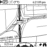
A severe limitation of UbiGo is the size
of its maps. Be prepared to dedicate one to two megabytes of memory
to UbiGo. if you live in a major metropolitan
area. My map of Harris County, Houston, and a few area towns was
over 1.5 MB! At least you can pick and choose what cities within
a county you want to have. I rarely travel to Pasadena (especially
after that speed trap In terms of customization, you cannot adjust the text size, but in Map | Preferences you can setup the greyscale shade and thickness (single or double) for the types of roads. You can also use the drawing tool to create your own maps.
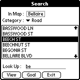
One caveat: you can only search by the beginning of a word (in the screen
shown, typing "nut" would not pull up Beechnut St.). You have to
also watch out for roads that have two names. Decker Rd is also called
Spur 55 (I think
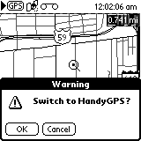
When exiting UbiGo or the HandyGPS application you will get a warning. That is because the GPS won't function anymore when in other applications. The satellites last locations are kept, though, so you can reconnect more quickly. UbiGo does not come with the HandyGPS --
you must download it from Nexian's website. UbiGo is free for one
year, after which you must pay $9.99 per year for new maps. |
Update: Auction Update / VisorAdventure 2 Thu Oct 11 - 12:05 AM EST InnoGear PowerCradle (updated) Tue Oct 9 - 10:51 PM EST iambic Office suite Thu Oct 4 - 1:12 AM EST Prism dropped to $299 Tue Oct 2 - 6:19 PM EST New Portable Keyboard Tue Oct 2 - 4:46 PM EST |
| About VisorCentral : Copyright ©1999 Smartphone Experts All rights reserved : Terms of Use : Privacy policy |
 First
off, you can forget everything you learned inside the HandyGPS application.
The only icon at the top of the screen that works is the GPS button.
The tape icon does nothing but blink some the screen. Only the bottom
icons of the UbiGo screen work: there is a
zoom arc (you can also use the up/down buttons), a drawing tool (make your
own maps!), a Point of Interest (POI) marker (a tack), and a search button
(binoculars).
 The
Search feature is pretty nice. You can
either search inside a particular map for a particular road, airport, etc.
and you can either view the item or mark it as a Goal. UbiGo
will show a box at the top right with the distance to the target.
 The
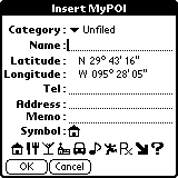
one thing I like about UbiGo is the Point-Of-Interest (POI) feature.
Tap the tack icon, then anywhere on a map (unfortunately you can't specify
the exact coordinates). Tap the POI icon again to enter the location's
information and select an icon for that POI. I wish POIs and Waypoints
were compatible. It would be nice to use the house and other icons
inside the HandyGPS application.

