 | |
| news | articles | reviews | software | modules | accessories | discussion | faq | mobile | store | |
| visorcentral >> reviews >> springboard modules >> geode | |
Geode
Using the Map 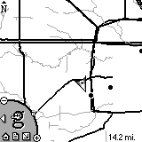 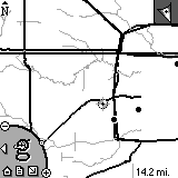 I
really like the way that the Geode uses the digital compass when in map
mode. When you have a solid fix, you will see an arrow indicating
your position and the direction you are facing. I
really like the way that the Geode uses the digital compass when in map
mode. When you have a solid fix, you will see an arrow indicating
your position and the direction you are facing.
If you lose the fix, the Geode puts a marker on your last known position and places a compass indicator at the top right of the screen. By doing this, you at least know the direction you are going even if you don't have an exact fix on your location. This is one of my favorite features of the Geode. It makes the module useful even when you lose your satellite fix.
Things stored on the Geode One of the Geode's best features out of the box is that it stores useful data on the module, alleviating the need to store it on the Visor's memory or on an MMC. Quick Tips is the user documentation, and is actually useful when compared to other help files. For example, I found these two power tips inside Quick Tips: draw L while in a map to get Lat/Long, altitude, status, and direction; draw a C to create a Geode Point based on your current location. Also stored on the Geode is a High Level World Map. World Cities, Major US Freeways, and Major US Water. All of these files would have almost totaled an additional megabyte of storage you would have needed. Kudos to Geode for including these on the module. MMC Storage
|
Update: Auction Update / VisorAdventure 2 Thu Oct 11 - 12:05 AM EST InnoGear PowerCradle (updated) Tue Oct 9 - 10:51 PM EST iambic Office suite Thu Oct 4 - 1:12 AM EST Prism dropped to $299 Tue Oct 2 - 6:19 PM EST New Portable Keyboard Tue Oct 2 - 4:46 PM EST |
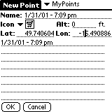 Find
a great spot that you want to remember or share with others? Create
a GeoPoint by selecting Action | Create Point. On this screen you
can select the database to store your entries (MyPoints is the default)
and give your point a name and icon. You can also type in notes for
the point.
Find
a great spot that you want to remember or share with others? Create
a GeoPoint by selecting Action | Create Point. On this screen you
can select the database to store your entries (MyPoints is the default)
and give your point a name and icon. You can also type in notes for
the point.
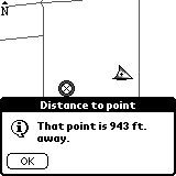 If
you tap on a blank area on the map you will be given the option to set
that location as a Target, recenter the map around that location, or create
a point where you tapped. I have here a picture of what a Target
looks like and the distance screen. As I said before, I couldn't
figure out how to de-select a Target.
If
you tap on a blank area on the map you will be given the option to set
that location as a Target, recenter the map around that location, or create
a point where you tapped. I have here a picture of what a Target
looks like and the distance screen. As I said before, I couldn't
figure out how to de-select a Target.
 At the time
that this review was published, GeoDiscovery hasn't finished the GeoData
Manager application that will let you store Geode maps on the two
MMC slots of the Geode. According to GeoDiscovery's website, they
"anticipate availability before the end of February." I will update
this portion of the review after the GeoData Manager's
release.
At the time
that this review was published, GeoDiscovery hasn't finished the GeoData
Manager application that will let you store Geode maps on the two
MMC slots of the Geode. According to GeoDiscovery's website, they
"anticipate availability before the end of February." I will update
this portion of the review after the GeoData Manager's
release.

| About VisorCentral : Copyright ©1999 Smartphone Experts All rights reserved : Terms of Use : Privacy policy |